Inside the Pleiades maps
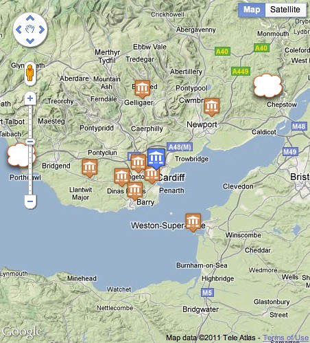
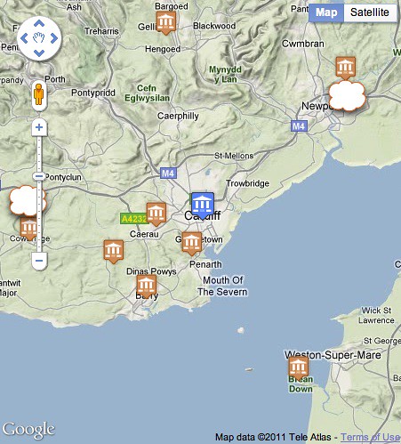
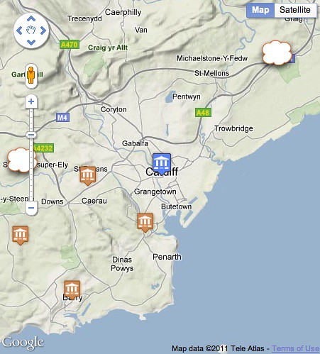
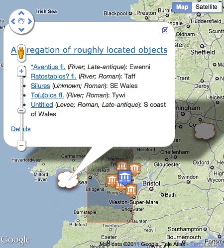
Representing roughly located places in a map is one of the more interesting technical challenges of Pleiades. I've been through a few iterations and have finally settled on aggregating roughly located places by their common bounding boxes and portraying them as a cloud in the map. There are two of these in the neighborhood of ancient Cardiff: the one to the east representing some large Roman administrative regions, the one to the west representing a few rivers and other imprecisely located places of Roman-era Wales.

What makes this different from the common point clustering approaches is that these cloud markers, at smallish scales, hover around the edges of the map pane to suggest that they are "somewhere" on the horizon of the neighborhood.

This effect is produced by sliding the markers along a line through the context and aggregate box centroids. Zoom in and the cloud approaches the context centroid.

Zoom out and it approaches the the far side of a circle circumscribing the aggregate bounding box. On a mouseover event the aggregate bounding box itself is shown, and the members of the aggregation are listed in the cloud marker's popup bubble on a click event.

I've wanted to accomplish this in a way that's as transparent and declarative as possible. The aggregate data is given to the client (Google Maps API in my case) in a JSON format. The line along which the markers will slide is represented as a GeoJSON LineString, but the feature itself is given a special "pleiades.stoa.org.BoxBoundedRoughFeature" type to distinguish this particular hovering-around-the-horizon kind of feature from a default GeoJSON feature. The javascript client running in the Pleiades page interprets this feature's data appropriately and displays it not as a line, but as a lurking object anchored to a variable point.
{
  "bbox": [
    -5.0,
    50.0,
    0.0,
    55.0
  ],
  "features": [
    {
      "bbox": [
        -5.0,
        50.0,
        0.0,
        55.0
      ],
      "geometry": {
        "coordinates": [
          [
            -3.1805009999999996,
            51.509679984152292
          ],
          [
            1.992620138265649,
            53.60762000668263
          ]
        ],
        "type": "LineString"
      },
      "id": "(-5.0, 50.0, 0.0, 55.0)",
      "properties": {
        "description": "<div>...</div>",
        "link": "http://pleiades.stoa.org/search?...",
        "snippet": "5.0 degree by 5.0 degree cell",
        "title": "Aggregation of roughly located objects"
      },
      "type": "pleiades.stoa.org.BoxBoundedRoughFeature"
    },
    {
      "bbox": [
        -4.0,
        51.0,
        -3.0,
        52.0
      ],
      "geometry": {
        "coordinates": [
          [
            -3.1805009999999996,
            51.481298999999993
          ],
          [
            -4.4406943342012717,
            51.565821152330514
          ]
        ],
        "type": "LineString"
      },
      "id": "(-4.0, 51.0, -3.0, 52.0)",
      "properties": {
        "description": "<div>...</div>",
        "link": "http://pleiades.stoa.org/search?...",
        "snippet": "1.0 degree by 1.0 degree cell",
        "title": "Aggregation of roughly located objects"
      },
      "type": "pleiades.stoa.org.BoxBoundedRoughFeature"
    }
  ],
  "id": "79706",
  "type": "FeatureCollection"
}
In the interest of transparency, this data is encoded in the web page using a JSON Data URI. There's no web service endpoint or data tucked away inside javascript; any client code can get the data from the <link> element with rel="r-where" in exactly the same way the Pleiades javascript does. I'm not saying this is the one true style of web mapping, but it's a style that I find very intriguing right now.
Comments
Re: Inside the Pleiades maps
Author: Peter Rushforth
Sean,
I dont' see rel="r-where" in your listing? What does r-where mean? Roughly where I suppose. If the r-where relation were defined in a
public link relationsrepository, I would tend to agree that it is a good way to convey map semantics.
Other good link relations could be "east", "west","north-east" etc for common map operations like panning. Zooming could be "zoom-in", "zoom-out".
Re: Inside the Pleiades maps
Author: Sean
Yeah, this rel type is nowhere (pun intended) near standardized. I'm still experimenting with this pattern. Speaking of map panning and zooming types, You might be interested in Erik Wilde's work on tiled feeds: http://dret.net/netdret/docs/oracle11/.