A more perfect union, continued
On to cascaded unions for Shapely ...
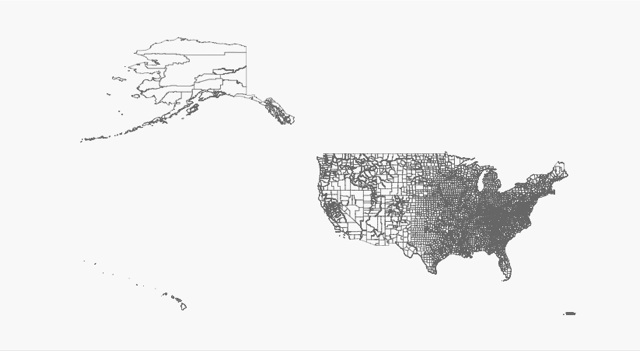
>>> from osgeo import ogr
>>> from shapely.wkb import loads
>>> ds = ogr.Open('/Users/seang/data/census/co99_d00.shp')
>>> co99 = ds.GetLayer(0)
>>> counties = []
>>> while 1:
...    f = co99.GetNextFeature()
...    if f is None: break
...    g = f.geometry()
...    counties.append(loads(g.ExportToWkb()))
...
>>> len(counties)
3489
Matplotlib makes a pretty picture of those 3489 polygons:
>>> import pylab
>>> from numpy import asarray
>>> fig = pylab.figure(1, figsize=(5.5, 3.0), dpi=150, facecolor='#f8f8f8')
>>> for co in counties:
...    a = asarray(co.exterior)
...    pylab.plot(a[:,0], a[:,1], aa=True, color='#666666', lw=0.5)
...
>>> pylab.show()
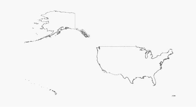
Shapely never had the power to dissolve adjacent polygons in a collection before, or at least not over large collections of real-world data. GEOS 3.1's cascaded unions are a big help:
>>> from shapely.ops import cascaded_union
>>> u = cascaded_union(counties)
>>> len(u.geoms)
219
>>> for part in u.geoms:
...     a = asarray(part.exterior)
...     pylab.plot(a[:,0], a[:,1], aa=True, color='#666666', lw=0.5)
...
>>> pylab.show()
There's user interest in leveraging the new reentrant API in GEOS 3.1, and releasing the GIL when calling GEOS functions to improve performance in multithreaded apps. I'm all for it.