2007 (old posts, page 29)

Peutinger's Map

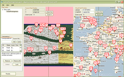
"Peutinger's" map, about which geo blogs are buzzing today, also happens to be the subject of work at the Ancient World Mapping Center. Pleiades and the Barrington Atlas cite Miller's 1916 study, the Itineraria Romana.

Comments

Re: Peutinger's Map

Author: Dave Smith

Thanks so much for the article - I particularly picked up on this part:
Despite the general familiarity of the image, however, few people have troubled to ‘read’ it, and even those few have typically limited their attention in a very localized way to the aspect which dominates the one full study ever made — namely, the extent to which the routes and distances shown are an accurate reflection of attested conditions on the ground. Moreover this study, entitled Itineraria Romana and published as long ago as 1916 by the amateur scholar Konrad Miller, is now hopelessly outdated; but still no-one has yet dared to address the map from any other perspective. Most recently (since the late 1980s), the broad debate concerning Roman ‘map consciousness’, or the lack of it, has acted as an additional deterrent to novel lines of enquiry.
I guess I can count myself among the few who have actually read it, I've worked out a number of the Latin inscriptions, have tied many (close to 200 so far) of the routes and placemarks to modern day, and have sorted out some of the many quirks of the map. I'm indeed working to understand it on a deeper level toward understanding the Roman understanding of their geography. I would imagine that accessibility of the map by scholars was likely an issue in years past...
Wikipedia Cabal Cablooie

The infamous community anti-pattern strikes again.

Comments

Re: Wikipedia Cabal Cablooie

Author: Allan

Yeah, I read that, too, thinking that every community has its backchannels. And every backchannel probably has backchannels.

Geo Microformat

Kurt Schwehr's post about hCard reminded me of something I had been thinking about before Thanksgiving: the geo microformat needs to be towed into the shop for a major makeover. Compared to GeoRSS or GeoJSON it has very little power. I'm interested in applying hAtom to the Pleiades XHTML docs. Add location and I'd have something like an "hGeoRSS", but the geo microformat isn't going to be adequate for expressing the locations of Pleiades roads or regions.

New Geospatial Packages for Zope

As part of my work on migrating Pleiades to Plone 3, I'm distilling Zope packages from the original old-style Plone products. The zgeo.geographer introduces the conventional GIS data model of geometries, features, and collections (ala GeoJSON) to Zope and describes an interface for annotating objects with geographic location metadata. The zgeo.spatialindex provides a container-local R-Tree spatial index for geographically annotated objects, enabling fast spatial bounding box searches.

Comments

Re: New Geospatial Packages for Zope

Author: J.F.

Excellent news!

Fake Ed Parsons

Funny. Yesterday I would have bet that a fake Jack Dangermond would have been the first to appear. Ed really set himself up for this by being such a stark raving Apple fanboy.

Agile Schmagile

Just kidding, Dave. I know people feel the same about REST. There's some similarity between the Agile and REST movements: each really got going about 6-7 years ago and have only just now reached the GIS industry mainstream.

Comments

Re: Agile Schmagile

Author: Andrew Turner

Well, you could say that REST is finally reaching "mainstream" in general.

Re: Agile Schmagile

Author: Sean

Yes. I was introduced to XP in 2001, but now I'm more "post-XP" or "post-Agile". The processes just don't fit distributed open source development without modification.

Watching the Watchers

"Domestic Spying, Inc." via an All Points Blog post is a interesting look at GEOINT and the corporations who profit from expanding the War on Terror's home front. In comparison, the GIS media coverage of GEOINT was pretty much what you'd expect from a Trekker's account of Star Trek Con. Kirk Kuykendall also has commentary.

Geo Products Example Buildout

I've made a Plone 3 buildout to get people up and running with reliable versions of PleiadesGeocoder, SpatialIndex, and all their dependencies. You can get it from our repository, build it up, and start it like so:

$ svn co http://svn.gispython.org/svn/zope/geo-products-example/trunk pgx
$ cd pgx
$ python bootstrap.py
$ ./bin/buildout -v
$ ./bin/instance start

Create a Plone site through the ZMI, install the PleiadesGeocoder and SpatialIndex products through the Plone control panel, and you're all set to geocode and spatially index content. Unfortunately, it's not going to work on Windows. I haven't even started looking into how to build GEOS or the spatialindex lib on win32.

Comments

Re: Geo Products Example Buildout

Author: Howard Butler

GEOS should build just fine on Windows if you use the 3.0 branch. spatialindex is buildable on win32 with cygwin, but I couldn't get it to produce a linkable dll. I think mostly just elbow grease or nmake files is needed to make it go :)

Map of the Napa-Bordeaux Greenline

There's an interesting map in "Red, White and 'Green': The Cost of Carbon In the Global Wine Trade," a paper by Tyler "Dr Vino" Colman and Pablo Paster.

http://sgillies.net/images/greenline.jpg

The authors find that transportation from vineyard to glass is the major factor in a bottle of wine's carbon footprint, and that east of the of the line the greater efficiency of shipping by boat offsets the distance between Bordeaux and Napa. See Colman's blog post for more. I can already visualize how an online version of their calculator would work.