Quad Rock 50 recap
Week 19 was race week. I ran the Quad Rock 50-miler for the second time, finished, and beat my 2019 time by 23 minutes. My official time: 12:50:34, 92nd of 211 race starters. This was the 3rd best time of the 19 50+ year-old dudes who started the race. Charlie Ealy, 57, finished 56 minutes ahead of me. Mike Teger, 52, finished one hour and 19 minutes ahead of him and was 24th overall.
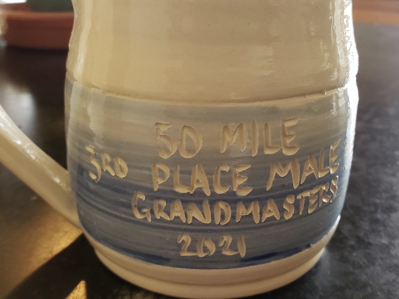
My first ultra-marathon trophy!
For me, the distinguishing feature of the race is its symmetrical sawtooth profile. After a gently rolling three mile preamble, runners take on three evenly-spaced 1,500 ft climbs, and then reverse course, six climbs in all. The middle 44 miles of the race course are 99% up and down, with an average grade of +/- 8%. This is not to say that all the climbs and descents are the same. Some are more technical, some are more exposed to sun and wind. Some have switchbacks, some go more directly up and down. I'm going to organize my recap of the race around its six summits, the introduction, and home stretch. I apologize for the lack of photos, I didn't carry my phone during this race.
Chapter 1: Start to Nomad Trail
I got a late start and had to run to the starting line because I was parked half a mile away. I found Mike Thompson there, who I know from the local OpenStreetMap activities that he has organized, and we ran together up the graded dirt road to the Arthurs Rock trailhead and south from there on the red clay single track that rolls along the west edge of the valley between Lory State Park and Horsetooth Open Space. While enjoying conversations with Mike, I made a mistake that I've made before, which is forgetting to eat early in the race. By the time we started to climb, it had been 100 minutes since I finished my bowl of cereal at home. In hindsight, I was playing catchup all day long.
Chapter 2: Up Sawmill and Towers, down Spring Creek
I started the race with one 500 ml bottle of Tailwind solution (2 scoops) in the front right pocket of my lightest vest, my old Camelback, and another soft bottle with powder but no water in the back along with my ultralight nylon jacket, cap, sunglasses, and candied ginger cubes. I went as light as I thought I could get away with. No beanie, no gloves, no first aid kit, and no phone. I started sipping my drink as we hiked up Sawmill and started eating some ginger cubes once we got onto Towers. Mike outpaced me on the "Super G" segment of Towers and I would not see him again for hours. Towers trail is a steep, but not technical climb that I know very well. I have gone up it much faster, but I wanted to keep some energy in the bank.
The Towers aid station is at the top of Quad Rock's first climb. There I filled my emptied bottle with water, tightened my shoelaces, and headed down the Spring Creek single track. It starts out steep and rocky, but then mellows out for a mile. I caught up to a group led by Michelle Flenner and followed them down the next rocky sections to Horsetooth Falls and then on to the rolling trail to the Horsetooth Trailhead aid station at mile 10. This was my fastest ever descent of Spring Creek. I arrived in 137th place, back of the midddle of the pack.
Chapter 3: Up South Ridge, Horsetooth Rock, Westridge trails, down Mill Creek
At the Horsetooth aid station I grabbed more Tailwind mix from the drop bag that I had sent ahead (thank you, race directors!), mixed up a fresh bottle, chugged some Coke and water, took half a banana and a small piece of ham-and-cheese sandwich and headed back out and up the wide and rocky South Ridge service road. I ate the sandwich early on South Ridge and saved the banana for later. Quad Rock's second climb is, in my opinion, its second hardest. South Ridge is non-technical, but steep, and then the race route splits off onto the steep and rather technical Horsetooth Rock trail. It has steps, rock gardens, roots, more steps, and raw granite scrambling. I ate the banana while hiking the higher, slower section. Past the turn-off to Horsetooth Mountain, the Westridge trail rolls and climbs choppily to the base of the communication towers and then descends gently to the Towers aid station. On my second visit, I checked in at 130th place.
I chugged some more Coke, filled a bottle with water, and headed down Mill Creek towards the next aid station, 3.5 miles away. I didn't pick up any food because I avoid eating on descents. Mill Creek is one of our more wooded trails and is largely on north-facing slopes. Snow lingers here, but was all melted before Saturday, leaving only a few mud patches and small streams. The single track varies between runnable sandy soil strewn with pine needles and heavily eroded chutes of rubble and dust, and there's a fair amount of climbing tucked away within the 1,400 ft of net elevation loss. I slipped once or twice but avoided crashing. Near the bottom, I was passed by the first 25-mile runner, Jonathan Rea (finished in 3:21:55). I'm not sure what place I was in when I arrived at Arthurs aid because my check in got lost between the timers table and OpenSplitTime. My family was a little alarmed when I went missing!
Chapter 4: Up Howard and Timber, down Timber trail to the turn-around
I chugged more Coke and water at the aid station, made one bottle of Tailwind, and took another bottle of water and two cookies for the relatively long leg up and down the Timber trail to the 25-mile mark. A couple more 25-mile runners passed me as I climbed up the gully from Arthurs and then I began to encounter the first 50-mile runners who had already turned around the course. The first half of Quad Rock's third climb was on the Howard trail's 13 sunny switchbacks. They go from fairly runnable at the bottom to less runnable near the top. The upper half rolls through burn scars and pine groves with long stretches of soft, shady, pine-mulched single track. This is my favorite of Quad Rock's climbs.
Like Mill Creek, the upper Timber descent is also in the shade of pines on a north-facing slope. It's consistently steep but less bombed-out than Mill Creek. I know this trail well and felt comfortable running just a bit slower than my fastest pace. I caught up with Mike, who was struggling with indigestion, here, and tried to encourage him as much as I could before speeding ahead. Halfway down there's a bridge across a creek and the trail suddenly switches to the open and sunny slope on the other side of the creek. At this point, it was 11 a.m. and getting quite warm, warmer than I'd expected. 50-mile runners coming back up from the turn-around began to show signs of suffering. I had developed a pretty serious hot spot on the inside of my left heel on the descent and was suffering a bit, myself.
Chapter 5: Up Timber, down Howard
At the Soldier Canyon aid station, mile 25, I chugged 24 ounces of Coke and water, ate two pickle spears and some watermelon, and put two thirds of a banana in my vest. Then I made a bottle of Tailwind and filled the other with water. I pulled my cap out of my vest, soaked it thoroughly, put on sunglasses, and headed back out towards the simmering switchbacks of the lower Timber trail. According to OpenSplitTime, I arrived in 114th place and left in 99th place. I think this means that 15 of my immediate peers dropped out at the 25-mile mark rather than reverse course and go for 25 more.
At the bottom of the climb, I met another older gentleman in a Hawaiian shirt named Ray. We kept each other company on the climb and cheered when a breeze began and took away the sweltering heat until we reached the little bridge and shade on the other side. The upper Timber trail is nicely constructed. Its 13 switchbacks keep the narrow path at a fairly constant 10% grade. We hiked of all this, squeezing past a mix of descending runners from both the 25 and 50-mile fields.
When it flattened at the top, Ray wasn't yet ready to run, so I took off by myself, crossed over the top of Lory and joined the Howard Trail for the last 2 miles down to Arthurs aid station (visit number 2). Warm conditions returned and the faces of runners ascending Howard were quite flushed. I felt the hot spot on my left heel blossom into a blister and experienced some mild cramps in my calves, but pushed on to the cool creek at the bottom, stopping briefly to splash my head and soak my cap. I arrived at Arthurs aid in 102nd place, ate some pickle spears and potato chunks, mixed one drink bottle, and headed out for the next climb.
Chapter 6: Up Mill Creek and Westridge, down Horsetooth Rock and South Ridge
Quad Rock's fifth climb is its toughest. Mill Creek has the most elevation gain and a constantly changing grade, with stretches up to 20%. At 34 miles, I was beginning to pay for inadequate feeding and felt sluggish and unsteady. I hiked it at a slow but steady pace with a pair of other runners in tow, leaning on my history with this climb and on cool water at stream crossings. We reached the Towers aid station for the third time about 15 minutes later than I do on shorter training runs. According to OpenSplitTime, I was in 94th place at this point. I took a bottle of water and a cup of M&Ms, and shuffled out toward the Westridge trail and the descent to the Horsetooth aid station.
I struggled across Westridge and down the steep and rocky Horsetooth Rock trail, leaning on anticipation of a gear change at the 40 mile mark. When I hit the wider South Ridge trail, I found I was able to run and let gravity do the work all the way to the bottom. I arrived at the aid station in 95th place.
Chapter 7: Ten miles to go. Up Spring Creek, down Towers and Sawmill
I took drinks, pickles, and salted pan-fried (yes!) potatoes, and sat down with my drop bag. In it I had stashed stashed lighter and more stable shoes, the Nike Terra Kigers that I wore at last year's Black Squirrel and on my last hard training run, and fresh socks to go with them. The blister on my heel didn't look as bad as I'd feared and I left it untreated, putting all my money on the better heel fit of my Nikes. There were clouds in the sky, but no immediate threat of rain, so I also traded my running vest and all its contents, jacket included, for a hand-held bottle. With one more fully equipped aid station and access to water at Arthurs between me and the finish, this seemed quite safe. I took a gel packet in a pocket just in case.
My legs creaked when I stood up again. It's not without reason that experienced ultra runners advise you to avoid sitting down. But my feet felt good and I could detect an increase in available energy from the candy I'd digested on the previous descent. I thanked the volunteers and shared my optimism with other runners at the station who looked low. It is true that Quad Rock's 6th climb is not particularly challenging by itself. Much less intimidating, for me, than the Mill Creek climb.
My plan was to run the last ten miles like it was a two-hour training run. I hiked and ran easily, when the grade flattened or dipped down, up to the Towers aid station (my fourth and last visit). I chugged some ginger ale, mixed a bottle of Tailwind, said good bye to the Towers volunteers for the last time, and headed down Towers trail. This is the 4-WD road that I've been using to develop my descending pace in the past few weeks, and I let my legs spin freely on the way down. I caught up to a fairly large group at the bottom of Sawmill and then was back on the red clay single track that rolls through the last 3 miles to the finish.
Chapter 8: Home stretch
I sucked my gel and ran all the downhills and hiked all the uphills, falling just off the back of the pack. I was impressed with how much energy those folks had at the end. I thought I was going to pass them, but they must have been only taking it easy on the last descent. I have a history of struggling on this home stretch and have written about it in other blog posts. I did better this time and never had the sensation of going backwards relative to other runners. I even moved up two places. With a half of a mile to go, I saw my family on the trail, and picked up my pace a tiny bit. There's a tiny climb before the finish, but the final 150 yards are all downhill, making it easier to finish with a smile. I did, and then found a place to lay down until a small wave of nausea passed.
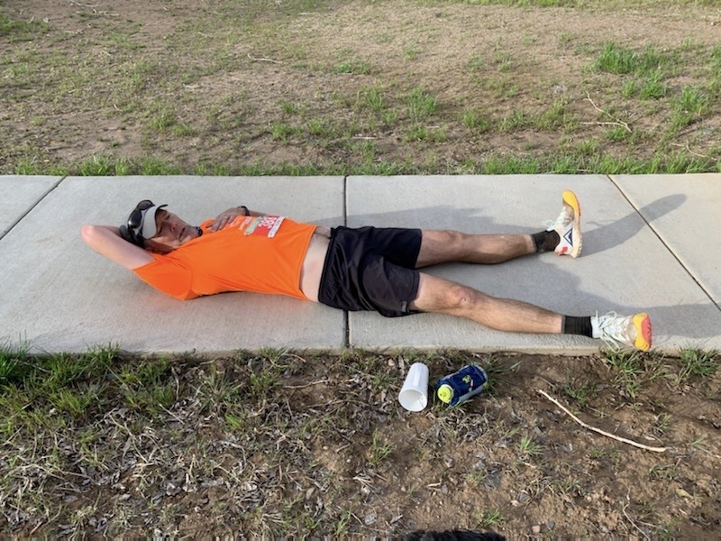
All done
Here are the final numbers for the week.
13 hours, 41 minutes
62 miles
10,675 ft D+
I did not do this alone. Thank you, volunteers, race directors, fellow runners, and my wonderful family. The last 19 weeks have been both challenging and satisfying.